A geographic information system (GIS) integrates hardware, software, and data for capturing, managing, analyzing, and displaying all forms of geographically referenced information.
GIS allows us to view, understand, question, interpret, and visualize data in many ways that reveal relationships, patterns, and trends in the form of maps, globes, reports, and charts.
A GIS helps you answer questions and solve problems by looking at your data in a way that is quickly understood and easily shared.
GIS technology can be integrated into any enterprise information system framework.
GIS is the merging of statistical analysis and computer science technology.
Generally, a GIS is custom-designed for an organization.
Hence, a GIS developed for an application, enterprise, or purpose may not be necessarily compatible with a GIS that has been developed for some other application, enterprise, or purpose.
It describes any information system that integrates stores, edits, analyzes, shares, and displays geographic information for informing decision making.
GIS applications are tools that allow users to create interactive queries (user-created searches), analyze spatial information, edit data in maps, and present the results of all these operations. Geographic information is the science underlying geographic concepts, applications, and systems.
Who uses gis?
Businesses, governments, educators, and scientists, environmental and conservation organizations, natural resource groups. Thousands of organizations use GIS to solve problems and improve processes. It helps us to learn best practices and get ideas on how we can implement GIS in our organization or community.
Top 5 GIS Software Applications
- Google Map Pro
Explore worldwide satellite imagery and 3D buildings and terrain for hundreds of cities. Zoom to your house or anywhere else, then dive in for a 360° perspective with Street View.
Links: https://www.google.com/earth/
2.Arc Gis
Part of the Esri Geospatial Cloud, ArcGIS Online enables you to connect people, locations, and data using interactive maps. Work with smart, data-driven styles and intuitive analysis tools that deliver location intelligence. Share your insights with the world or specific groups.
Links: https://www.esri.com/en-us/arcgis
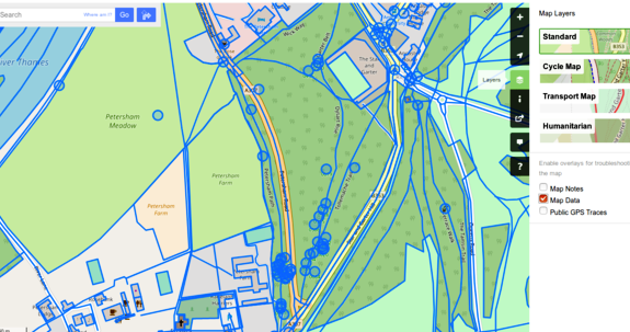
3.OpenStreetMap
OpenStreetMap is a collaborative project to create a free editable map of the world. The geodata underlying the map is considered the primary output of the project.
Links: https://www.openstreetmap.org/
4.QGIS
QGIS is a free and open-source cross-platform desktop geographic information system application that supports viewing, editing, and analysis of geospatial data.
Links:https://www.qgis.org/en/
5.Maptitude
Maptitude Geographic Information System (GIS) software gives you the tools, maps, and demographic data you need to analyze and understand how geography affects you and your business. Every day you have to contend with spreadsheets and databases filled with vast amounts of customer, employee, sales, facility, and territory data. With Maptitude mapping software you can visualize data in new and different ways, unearth geographic patterns hidden in your data, and convey that information in a straightforward manner. Maptitude provides everything you need to realize the benefits of desktop mapping and spatial analysis with a single, easy-to-use package.